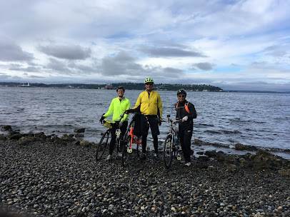
Directions

The first day out it became clear we were too dependent on an online mapping program set to cycling routes. Ida works in downtown Seattle, so she deftly navigated us from the sound through downtown and onto a great bike path. Once at the end of that path, it was a series of adventures until we found the start of the next path. Twice the mapping software took us too seriously. We found ourselves on beautiful single track mountain biking paths in the middle of the woods. The first one had switchbacks so steep we had to push our not-mountian-bikes up the hill. The second one was narrow, windy, and full of challenging tree roots and rock outcroppings. Again we pushed our not-mountian-bikes for that ½ mile section. A favorite memory of this trip will be Ida, balancing her bike on the rear tire as she tried to see the recommended directions on her phone that was in her handlebar bag. Ida was the navigator.
Ida successfully got us through the 414 mile ride inWashington. Ida had to leave to head back to work. The very next day, with Jon and I were left to our own navigational devices, we had to make a U-turn within the first ½ hour without Ida.
With a tailwind, we made 91 miles. On another day, with a 34 MPH gusting headwind, we struggled to ride 39 miles. There is a reason we don’t have a detailed route with all our sleeping locations marked. Some would say the varying conditions prohibit such a plan. I prefer to think of it as lack of proper planning and an inherent belief that it will all work out, as long as you keep the end in mind.
“Excuse me, do you know the way to Boston?”

Comments
Post a Comment